Exploring the Pryor Mountains Wild Horse Range
(Information and graphics courtesy of BLM, Billings Resource Area Office)
 Exploring the Pryor Mountain country is an opportunity to experience a land that has changed little since prehistoric people came to take advantage of relatively snow-free winters and year round sunshine in the lower foothills.
The Bureau of Land Management's Pryor Mountain Wild Horse Range is located on the south slope of East Pryor Mountain overlooking the Bighorn Basin of Wyoming. In addition to searching for the Pryor Mustangs, the rugged and mysterious Pryor Mountain country beckons the adventuresome to explore over the next ridge- into the next draw- for what might be discovered in this out-of-the-way land that few have visited.
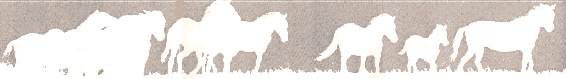
Approximately 120 wild horses range from the Pryors' high meadows down through rugged juniper-covered foothills to colorful desert-like badlands that border the green fields of Crooked Creek Valley. The many ridges and ravines give the mustangs room to roam and finding them is not guaranteed. This information summarizes the best places to start.
Note: You might want to call up The Pryor Mountains WHA Map in a second simultaneous browser session so that you can switch back and forth between the descriptions and the map.
Access to the range is from one of two roads described below. Both of these routes terminate at the junction marked "B" on the map. This junction is the starting point for both the Tillet Ridge and the Sykes Ridge Roads described below. Some sections of the roads within the range itself may challenge your driving abilities or the capabilities of your vehicle. Do not leave yourself without a margin of safety in this remote area.
(1) In Cowley, Wyoming, turn north from Main Street (Highway 310) onto Division Street which is the road to the airport. Division Street is bordered by a park and a water tower. Drive north on Division Street (Airport Rd.). In about 9.1 miles you will come to a junction that features a BLM sign which reads "Crooked Creek Left". DO NOT TURN LEFT! Continue about 3.5 miles more and turn left onto the cottonwood-lined gravel road that crosses Crooked Creek and joins County Road 16. At this junction a sign points left to Tillet / Burnt Timber Ridge and right to Sykes Ridge.
From Lovell, Wyoming, take US 14A for 2.4 miles east of town. Here turn north onto State Highway 37 and drive 9 miles to the Crooked Creek Road turnoff. The turnoff is less than one mile south of the Bighorn Recreation Area boundary. Turn from the state highway and go 1.7 miles west. Turn right on the cottonwood-lined lined gravel road that crosses Crooked Creek and joins County Road 16. At this junction a sign points left to Tillet / Burnt Timber Ridge and right to Sykes Ridge.
Beginning at point "B", turn right (east) on County Road 16, go 2.5 miles and turn left (north) just before the road goes into the fish hatchery. The Wild Horse Range boundary sign is approximately 100 yards north of Road 16. A second sign reads "Mystery Cave Road."
In an emergency, the closest telephone would be at the State Fish Hatchery. (See map)
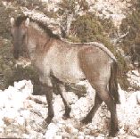 The first 3 miles of this road are usually dry year round and passable for cars, but the route is not maintained at regular intervals. Car drivers should proceed slowly watching for rocks and uneven ground. A short walk up the small hills at the red bluffs provides a view to the west overlooking Turkey Flats, where up to 30 wild horses have been seen in winter. Small bands of mustangs roam the juniper foothills year round, but many horses favor this area of Sykes Ridge from February through May.
Three miles from County Road 16 the road becomes extremely rough as it drops down into Sykes Coulee (see map). From this point on high-clearance vehicles with tough sidewall tires are required and four-wheel-drive is necessary. Stopping at the three-mile point offers a good hiking opportunity. Stay on the ridge and go exploring. This area is visited by few- who knows what discoveries await. All visitors will be rewarded by the sweeping view south into the Bighorn Basin. The low woody gray-green bushes in this area are mountain mahogany- a favorite winter food for mule deer.
After 8 miles, the road climbs onto the open rocky South Ridge of East Pryor Mountain. The views from South Ridge are truly outstanding. From this elevation (6,400' - 6,800') the sheer cliffs of Bighorn and Devil's Canyons can be seen to the east, The Bighorn, Beartooth, Absarokee, and Wind River Mountains frame the scene. Mustangs, mule deer and bighorn sheep migrate over this ridge to summer pasture. Travel beyond south ridge to the Dryhead Vista Road is usually not possible until July because of snowdrifts.
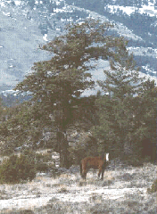
The road continues higher into forests of Douglas fir and limber pine and comes out into a grassy ridge top called Wild Horse Park. Rustic Penn's cabin is in this park. It is open for free public use on a first-come first-served basis. The cabin contains wood board bunks for sleeping bags and a wood stove. A dozen or so mustangs can typically be seen grazing on the grassy slopes near the cabin. There are a number of short (up to 2 miles round trip) hiking opportunities through the high mountain parks used by horses. Layout Ridge northeast of Penn's cabin is excellent. Slender subalpine firs ring the meadows, and the sweeping vistas of the surrounding mountains are worth a hike or picnic just in themselves. Have a coat available year round for the high country.
 Beginning at Point "B" turn left (west) on County Road 16 towards BLM's Britton Springs Corrals. Less than a mile beyond the corrals, and intersection sign points right (north) to the Tillet Ridge Road (Point "E"). This road is passable to high clearance 2-wheel drive vehicles. Drivers should proceed with caution and drive slowly. In spring, grass and water draw animals to the middle foothills areas- particularly from the vicinity of the old mines to the Forest Service boundary. Beyond the mines four-wheel drive and tough sidewall tires are needed.
Above the mines one can look west and see Demijohn Flat. For centuries prehistoric people came to camp on this grassy flat mesa. There is no water on the mesa, however, and if you look carefully from Tillet Ridge you can see a long, well defined trail down the steep cliff into Crooked Creek Canyon that these people traversed to obtain water. Why did they use this place when many other spots along Crooked Creek have grass, wood and adjacent water? No one has discovered the answer.
The road to Tillet Ridge passes BLM's Britton Springs Corrals. BLM's wild horse roundup usually occurs in March when horses are gathered at the corrals. Contact the BLM Area Office in Billings for definite details.
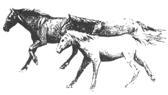
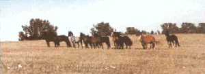
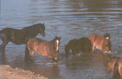
The wild horses roam over their range in bands from two or three up to 15 head. Usually these bands are a stallion with his mares and colts, but there are also bands of young stallions without mares. As the snow clears from the top of the mountains in early summer, as many as half of the mustangs are drawn to the grass of the high parks. When winter snows force them down from the mountain tops, the bands of horses will join those that stayed in the foothills and lowlands. Mares usually drop their foals during May. Soon afterward, the stallions challenge each other as they gather mares for their bands. This period is a time of wonderful photographic opportunities.
This is not a BLM operated or BLM sponsored site. It is run by private wild horse and burro enthusiasts. We are thankful to the BLM for providing the information which is presented here. We also hope to soon be posting information pertaining to HMAs in other states.